In the early 2000s West Sussex County Council began to look into options for closing all gaps on the A24 dual carriageway between Southwater & Ashington by providing several grade separated junctions or roundabouts at significant junctions along the A24. This was the result of a high level of collisions including several fatalities within a few years almost exclusively at the at-grade right turns.
As an initial measure in 2002 resulted in 60mph limits & speed cameras at some of the busy at-grade junctions, with development of a proper scheme being developed over the coming years. The most refined designs were produced in 2009 after many rounds of consultations. However was then completely dropped in 2011 due to not being value for money. Since the installation of speed cameras & lower speed limit in places, fatalities have dropped to 6 in the past 10 years (2011-2020), with only 2 of these being at right turns.
The scheme in general did have large public support, however as with all road projects there was an anti-improvement group worried with the increase of traffic these improvements would of bought, although this scheme was simply aimed at improving the safety and not capacity of the road in expectation of the increased demand due to large amount of new development in the area as well as addressing the existing safety concerns mentioned above.
In total the scheme was due to cost £35.3m (2008) (52.2m in 2022 prices) for starting construction in 2012/13. The county council was only going to have to pay for 10% of the works, whilst central government would fund the rest.
The scheme
The as outlined would result in:
Vehicle restraint system in central reserve
28 gaps closed in central reserve
Three new Grade Separated Junctions at Dial Post, B2135 & A272 Buckbarn
Service Roads & improved accesses for properties with direct access to A24
PRoW diversions & improvments
Hard Strips in certain places
Final 2009 Plans
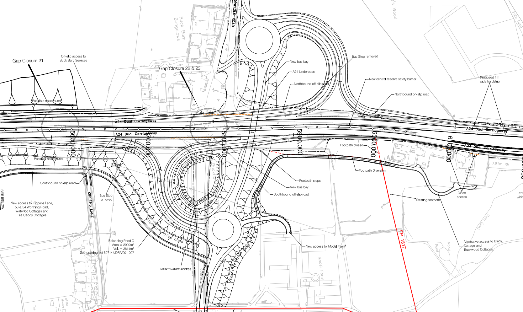
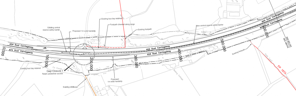
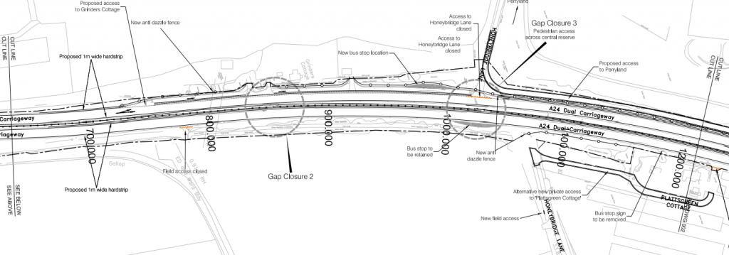
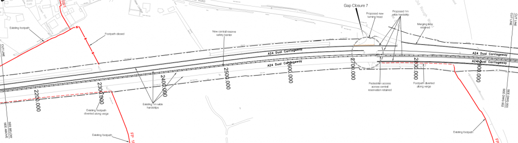
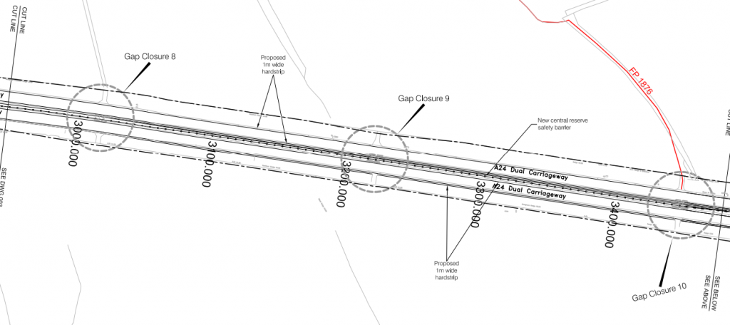
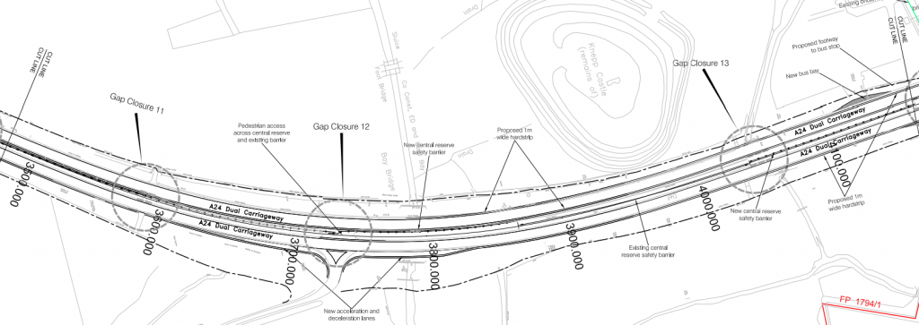
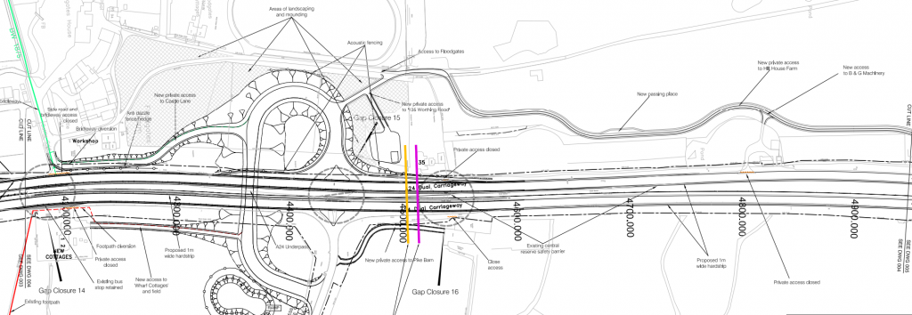
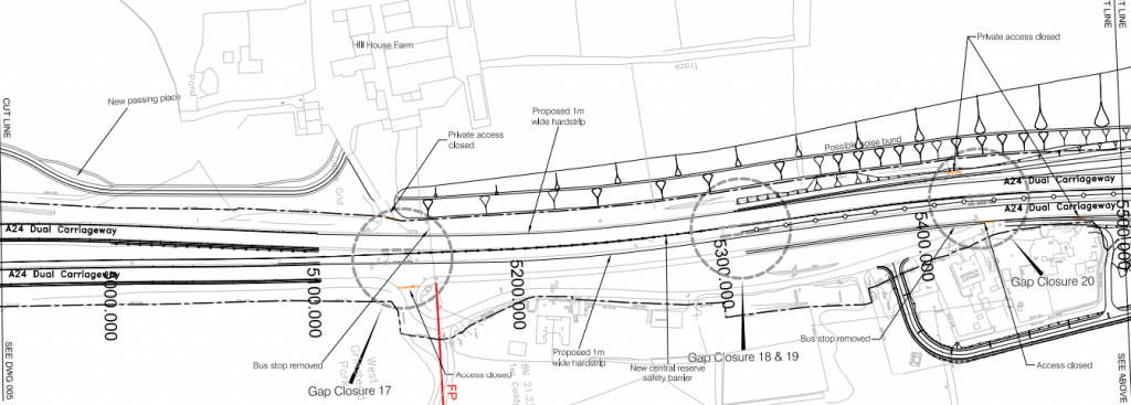
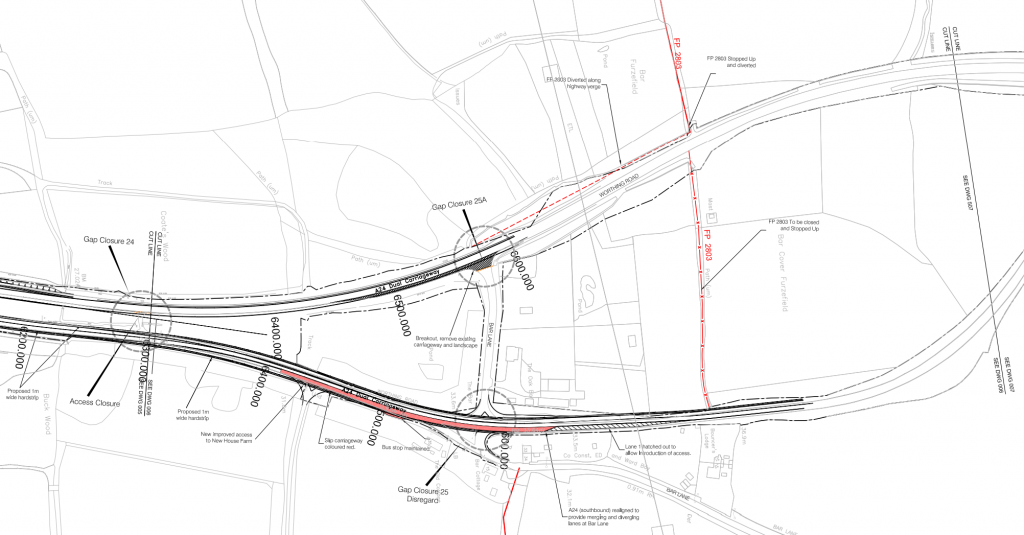
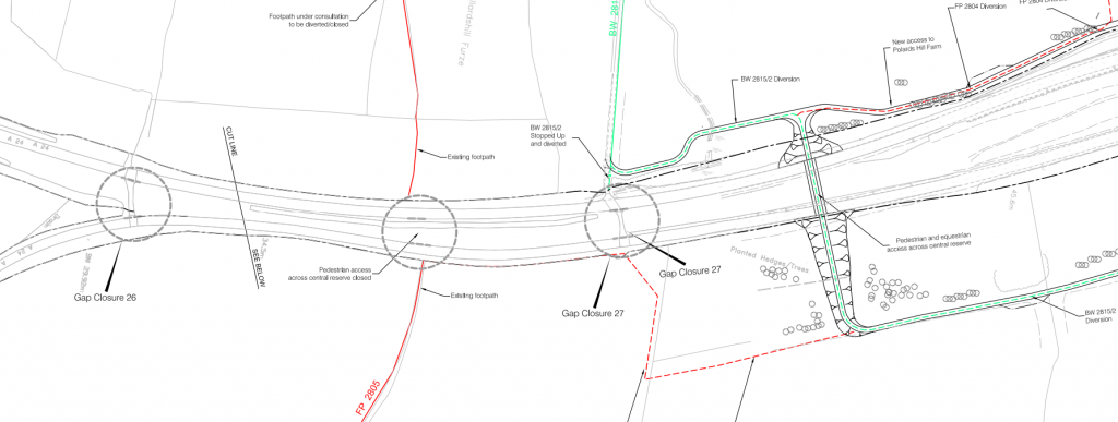
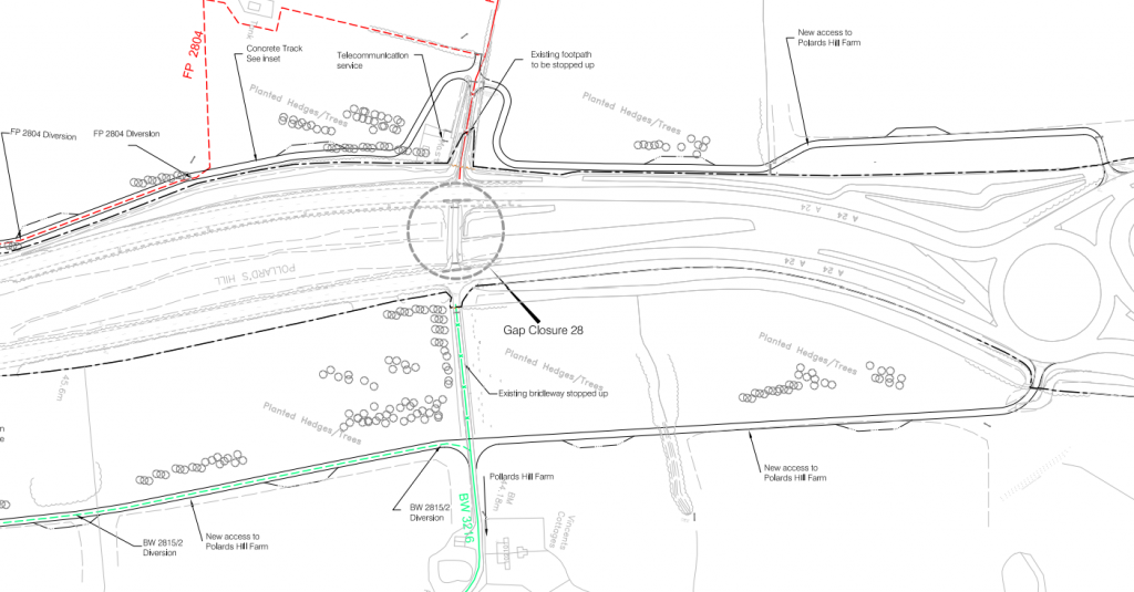
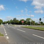
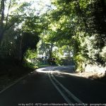
The scheme would start at the access road to Wincave Farm, this is the south most gap (ex ped) on the A24 North of Washington. Here the gap would be closed, however a staggered gap in the VRS would be provided for traffic crossing to/from the bridleway to the East.This next section would see two gaps closed, one is used for access to properties and the other for Honeybridge Lane (North). Properties on the Western side would have a single lane one-way segregated access road built in the current verge to allow for a low-speed entry and exit to their properties along with a bus stop relocated onto this. On the Eastern side access to Plattsgreen Cottages would be relocated onto Honeybridge Lane (South), however Google Street View suggests that this is the primary means of access since before 2009. Finally Honeybridge Lane (North) which provides access to Perrylands would have its access moved from the A24 dual carraigeway North to the next junction by building a new service road in the existing verge. Pedestrian access would still be provided at Honeybridge Lane closure.The next section would see a closure of 3 gaps & the first grade separated junction. All gaps are closed with no pedestrian access. The properties on the Western side have their access moved onto the service road continued from the previous section which would mostly be built in the verge, this service road would tie into the old A24 alignment. The existing Dial Post (south) junction would be moved slightly North where it would form a tight folded diamond interchange, although the southbound on-slip would be located near the garden centre. A new service road would be provided on the Eastern side between the new junction & old junction at the garden centre. In addition some PRoWs would be diverted to use the new underpass. It appears that the new crossing would be located under the A24, likely to reduce noise and visual impact to Dial Post. Other options were proposed here such as a roundabout or traffic signals, however both were unfavourable.At Dial Post (North), the Northbound on-slip will be retained, but the gap closed with exception of pedestrians.To the North of Dial Post some gaps would be closed which provide cross access to fields. It does appear that most of these access are no longer used except the north most one which provides access to a Public Footpath.The next section near to Bassels Lane would see three gaps closed. The first one is similar to the previous ones and is a disused field access. The Gap at Bassels Lane would be closed except for pedestrians and acceleration & deceleration lanes would be provided for easier access to and from the side road. Hard strips would also be constructed on the A24 along here. The gap for access to a field on the Eastern side would also be closed up, however a VRS was installed across here since before 2011 anyway.At B2135 we find our next GSJ. This one takes form as a compact folded diamond with an underpass under the A24. As well as providing a grade separated junction for the B2135, it would also provide the access points for service roads on all four sides. On the Eastern side access would head out North & South to connect to isolated dwellings, whilst on the Western side there are new private access roads heading North and South to Castle Lane (Knepp Estate). This would also see the PRoWs diverted onto the new crossing. Old Access to Castle Lane/PRoW crossing would be closed up.Between B2135 & A272 further gaps are closed up with no pedestrian access. Hill House Farm has its access diverted on the service road from the B2135 junction whilst the houses on the Eastern side, which currently use an access road which comes off of & on to the A24 will have its access closed from the A24 and a new access road would be provided that would connect onto the A272.The A272 junction would take form as a folded diamond with dual carriageway sliproads in a dumbell style layout with the A272 passing under the A24 slightly North of its current alignment. All gaps would be closed with no pedestrian access. Kippings Lane (private road) would have its access moved from the A24 onto the new Old Worthing Road service road. New access roads would also be provided to Model Farm & the various houses on the Eastern Side of the A24 north of the A272. Hard strips would also be added.At Bar Lane the A24 splits in two, with the Southbound Carriageway using an older bendier alignment which is limited to 50mph, whilst the Northbound carriageway is newer and is limited to NSL. Its out of the scope to realign the Southbound carraigeway here as it would involve removing mature woodland. This junction poses issues due to there being a property between the carriageways. Initial plans suggested closing off access to the Southbound carriageway due to the lack of deceleration lanes and crossing traffic whilst the Northbound carriageway has a right side deceleration and no crossing traffic. It appears that the final plans suggested removing access from the Northbound carriageway and instead narrowing the southbound carriageway to a single lane to provide deceleration lanes. The Public Footpath would also be diverted to use Bar Lane. Some work took place in 2015 to make this crossing safer, however it is still far from ideal.North of Bar Lane three more gaps are closed. The first one is disused, the second one isn’t actually a gap, its a PRoW crossing which is disused, it was proposed to move the Eastern Footpath to join the Diverted Bridleway to the North and remove the Footpath on the Western side which hasn’t happened. The next gap is where a Bridleway terminates onto the A24 but is also a field access. This gap has evidence of still being used, it was proposed to move this onto a new subway under the A24 just to the North. This is where the diverted footpath would connect onto. There also would be no central VRS here due to vegetation preventing cross carriageway collisions. The final gap closure at Polards Hill Farm would see its access diverted to Mill Straight, along with the PRoW crossing diverted to the new subway. The current gap here doesn’t really exist and complete overgrown & disused. There has also been new housing development on the Western side of the roundabout now.
The future?
Horsham District Council has highlighted the area between Buck Barn & West Grinstead as a potential site for a new town, with this the council has suggested a whole host of mitigation measures such as Grade Separating the Buckbarn Crossroads (A24/A272), however other improvements may also be made along the A24 corridor.
Its also been highlighted many times in recent years the A24 corridor needs attention for active travel, so its likely in the next few decades there will be a package of improvements which may leave the A24 as a mostly limited access, grade separated two lane dual carriageway with a parallel dedicated cycleway.